
The Alabama Water Institute’s Community-Oriented Nature-based Science for Ecosystem Restoration and Versatile Engineering, or CONSERVE, Research Group is developing digital twin ecosystems as part of an emerging portfolio for watershed conservation and management. The approach adapts technology long used in aerospace and industry, where digital replicas of physical systems help engineers monitor conditions and make real-time decisions, and puts it to work in the environment.
CONSERVE Director Dr. Michael Fedoroff described it as moving “a real-time industrial application into a real-time environmental application,” a shift he sees as redefining how CONSERVE approaches conservation science.
The shift is more than a technology transfer. It represents a new way of thinking about how conservation and restoration decisions get made, and how to understand their consequences before they play out on the ground.
A Living Model of the Ecosystem
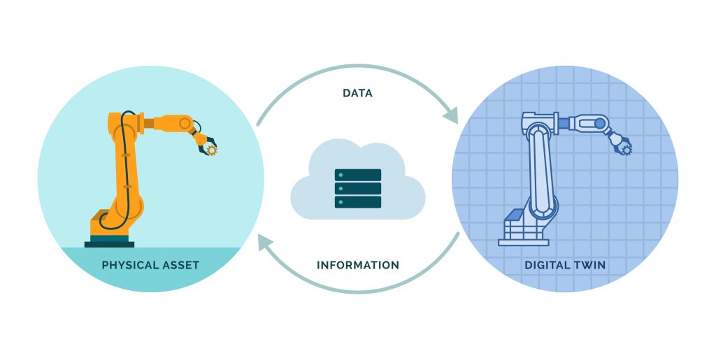
A digital twin is exactly what it sounds like: a digital replica of a physical system that reflects real-world conditions and updates as those conditions change. In industrial settings, digital twins have long been used to monitor equipment, predict maintenance needs and reduce risk. The underlying logic translates directly to ecosystems.
CONSERVE’s approach starts by building a digital version of an ecosystem under current conditions, drawing on data sets that include hydrology, soil maps, climate data, wildlife inventories and botanical plant surveys. Once that baseline is established, researchers can introduce variables and advance the model forward in time.
“Imagine a Google Earth slider where you can change the view to the past and you see how the land changed,” Fedoroff said. “You can now do that for the future when you put these variables in.”
The result is a tool that works in two directions. Researchers can use it to forecast future ecosystem conditions under different management scenarios, or they can use it to support decisions in real time as conditions on the ground shift.
Take native rivercane, one of CONSERVE’s key restoration priorities in the Southeast, as an example of how this could work in practice. A digital twin model could simulate where rivercane restoration efforts will have the greatest impact on soil health, water quality and erosion control over the next 20 years, helping researchers and land managers put the right plant in the right place at the right time.

Real-Time Data for Better Decisions
What separates a digital twin from a static model is the data feeding it. To keep the digital ecosystem current, CONSERVE has acquired monitoring equipment called phenodes, sensors placed directly in the ground that stream environmental data in real time.
“We’ve just purchased some monitoring equipment called phenodes that we can place in the ground,” Fedoroff said. “They have little wires that run off of them, and they test things like soil temperature, how much water comes across the landscape, climate data, evaporation rates and the amount of sunlight.”
Researchers and farmers often deploy multiple phenodes across different plots to collect and stream comprehensive environmental data to the cloud. All of that information feeds continuously into the digital system, allowing the model to reflect what is actually happening in the ecosystem at any given moment. They can spot patterns earlier, track the effects of restoration work as it unfolds and adjust their approach based on what the data shows rather than what they expect to find.
Building the Expertise to Match the Ambition
Developing digital twin ecosystems at the scale CONSERVE envisions requires specialized expertise the group sought to build deliberately. To meet that need, CONSERVE brought in one of the country’s leading voices in Geospatial Artificial Intelligence, or GeoAI, the field that provides the analytic and predictive capabilities that power digital twin systems.
Dr. Xinyue Ye, the Endowed Shelby Distinguished Professor in the Department of Geography and the Environment at The University of Alabama, serves as director of AI for CONSERVE. A globally recognized leader in the field, Ye’s research connects GeoAI with disciplines across the humanities and engineering, with a focus on digital twins, real-time 3D modeling and AI-enabled approaches to community resilience and sustainability.

“By integrating GeoAI, earth observations, sensor networks, scientific knowledge, and continuously updated environmental data, a digital twin becomes a living decision-support system. Instead of simply showing what the environment looks like today, it allows us to ask ‘what if’ questions, evaluate alternative conservation strategies before they are implemented, and support more informed, adaptive management,” Ye said. “Our goal is to help scientists, resource managers and communities make better decisions under uncertainty while building more resilient ecosystems.”
Ye’s role within CONSERVE follows the group’s corporate-service model, in which specialists provide expertise across the entire team rather than within a single project. Just as Dr. Bennett Bearden provides water policy guidance to all of CONSERVE and Dr. Mary Pitts brings watershed restoration expertise, Ye will make GeoAI capabilities available to every program and research initiative the group pursues.
A New Lens Across the Entire Portfolio
CONSERVE is not positioning digital twin technology as a standalone research program. The vision is more ambitious: to embed this approach across everything the group does.
“We see it as an emerging portfolio for CONSERVE, but not a standalone portfolio,” Fedoroff said. “We envision this type of approach in all of our projects.”
That means the aquifer recharge modeling underway through the Innovative Water Systems program, the genomics work mapping rivercane populations across 12 states, and the restoration projects taking shape in watersheds from West Alabama to the Big Canoe Creek could all eventually be informed by digital twin modeling. The technology does not replace any of those efforts. It gives each of them a new way to forecast changes in the future.
Grant proposals are currently in development to fund the next phase of this work. As those resources come together, CONSERVE is building the team, the tools and the data infrastructure to make digital twin ecosystems a defining part of how it does science.
The Alabama Water Institute is one of The University of Alabama’s research institutes. AWI acts as a forum for interdisciplinary research and education by bringing together University researchers, students and staff to foster collaboration and a broad interdisciplinary focus on water issues that face our world today. AWI-affiliated researchers specialize in hydrologic and hydraulic modeling, water security and quality, remote sensing, biodiversity and watershed management and human health through synergies with AWI research programs, including the NOAA Cooperative Institute for Research to Operations in Hydrology, the Global Water Security Center and the CONSERVE Research Group.