
Coauthored with Parker King
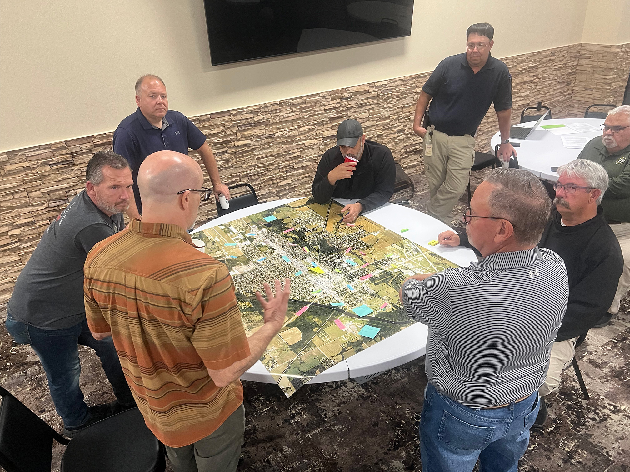
MIAMI, Okla. — Representatives from tribal nations and city officials gathered with University of Alabama researchers to address increasing flood risks affecting northeastern Oklahoma communities during a tabletop exercise focused on improving flood response and planning.
The event, led by CONSERVE Research Group Dr. Michael Fedoroff and funded by a NOAA CIROH grant, brought together emergency managers from Ottawa County, the City of Miami and several tribal nations including the Quapaw Tribe, Miami Nation and Wyandotte Nation to discuss flood challenges in the region.
Local Knowledge Reveals Complex Flood Patterns
This effort was a product of a multi-year engagement between The University of Alabama, Wyandotte Nation and the City of Wyandotte—who are full research partners on the project. The tabletop exercise included discussions on regional flooding experiences, identification of challenges and successes in flood management and a detailed retrospective of the area’s 2019 flood event. The session concluded with demonstrations of visualization tools designed to support local decision-makers.
Local emergency managers expressed that each flood is different in its own way, and that the source determines how it affects the area. Throughout discussions, it became apparent that tribal governments frequently support county and states resources, for instance the Quapaw Fire and EMS responds to emergencies countywide.
Other partners involved in the collaborative research effort include University of Kansas, University of Vermont, Northeastern University, Tribal GIS®, the Miami Nation, the City of Miami, Quapaw Fire and Rescue and representatives from NOAA’s National Weather Service.
The exercise highlighted the tremendous job done by local leaders and emergency responders in spite of several critical challenges in the region’s ability to respond to and mitigate flood damage such as:
- Coordination and jurisdictional challenges with both federal and state agencies, and municipal and tribal governments.
- Communication difficulties during flood events when road infrastructure is compromised.
- Economic development barriers due to recurring flooding.
- Housing shortages resulting from properties damaged in flood plains.
NOAA Tools Demonstrate Potential Solutions
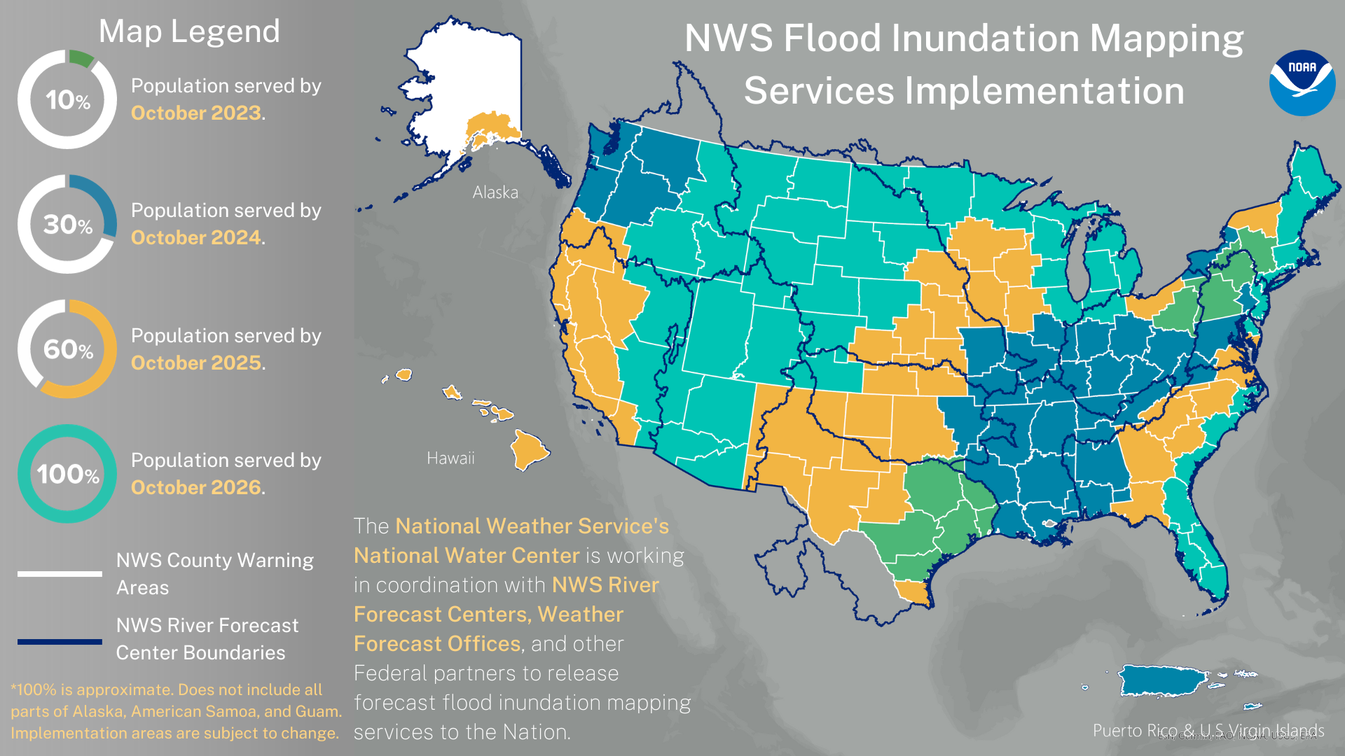
NOAA NWS’ Dr. David Vallee provided a desktop tour of existing tools that could support local decision-making including the National Water Model and flood inundation mapping products. These tools provide river forecasts, inundation maps and potentially valuable data for emergency planning.
Local participants expressed strong interest in visualization tools that could display flood depth and timing data. Emergency managers noted such tools would be particularly valuable for showing stakeholders and residents potential impacts, as “most everyone is a visual learner.”
Cross-Jurisdictional Collaboration Shows Path Forward
Following these discussions, the project team began developing a prototype visualization tool that could potentially demonstrate the national application of incorporating data from NWS gages across the country to visualize flood timing based on land use patterns.
Conceptually codeveloped with tribal and city partners, the tool has potential for informing emergency managers’ decision-making and improving messaging to encourage protective action. Participants repeatedly emphasized that each flooding event affects the region differently but with consistent devastation. Local emergency managers described how flooding has grown worse over 80 years with increasing sediment collection in the lake making prediction nearly impossible.
“Depth of the flood and how fast it would happen could be critical,” noted one participant during tool discussions, emphasizing features that would have practical application during emergency response.
“The tool could do a better job of demonstrating that not evacuating could cost your life,” noted another participant, highlighting the potential human impact of improved flood visualization technology beyond scientific applications.
Many community members and leaders feel that the city and county have never quite recovered from the area’s 2007 flood, with local officials citing continued challenges in economic development and housing availability in non-flood areas. The project represents growing recognition that addressing water security challenges requires collaborative approaches across jurisdictional boundaries. Participants emphasized the importance of continuing to “build local and tribal relationships, so we work as a team and not a locality.”
Next Steps Focus on Community Implementation
Next steps include further codevelopment of the visualization prototype with input from local emergency managers and community leaders and continued refinement of NOAA’s products to meet community needs. The timing of this work is crucial, as Ottawa County is included in NOAA’s 2024 rollout of enhanced flood risk management tools.
This locally driven, collaborative research highlights how cross-disciplinary approaches can enhance federal and academic responses to flooding challenges in vulnerable communities nationwide.
For local communities facing increasingly unpredictable flooding events, these collaborative research efforts represent a promising step toward more resilient planning and response capabilities in a region where flooding is overwhelmingly devastating for both economic development and everyday life.