
TUSCALOOSA, Ala. – In flood forecasting, small errors can have major consequences. Every year, families across the United States rely on flood maps to make critical decisions about when to evacuate and where to go. Therefore, it is critical to ensure maps are up-to-date and free of inaccurate assumptions.
This is the pursuit of CIROH researchers Dr. Yixian Chen and Dr. Sagy Cohen. Their work focuses on a critical but often overlooked variable in flood prediction: river slope. River slope is the rate at which water flows downstream, and it influences how quickly water accumulates and overflows. If the slope is off, models might underestimate flood risk, and communities could be caught off guard.
A Problem Hidden in the Elevation
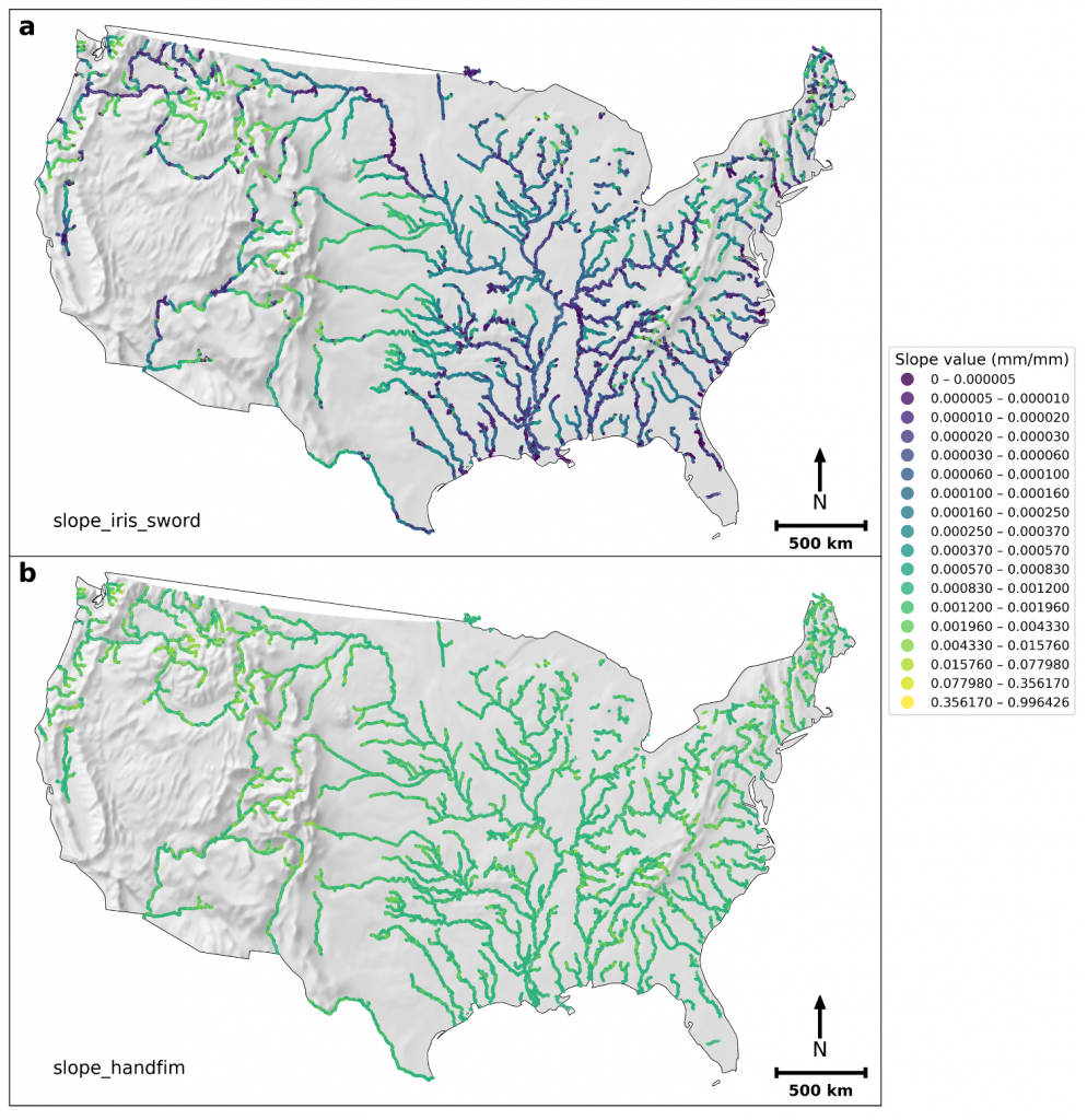
In existing models, river slope values are either too steep or based on old terrain data. This causes models to overestimate the amount of water required to trigger a flood. Consequently, some flood maps underpredict the actual extent of flooding, potentially delaying warnings and evacuation efforts for the communities that need them most.
A Satellite-Powered Solution
To address this, Chen and Cohen developed two new datasets—FIM HF IRIS and NextGen HF IRIS—using precise river slope measurements derived from NASA’s ICESat-2 satellite. The satellite uses a laser altimeter to capture recent water surface elevations with far greater accuracy than older elevation maps. The result is a sharper picture of how water behaves in low-gradient areas, where even minor errors in slope can skew forecasts.
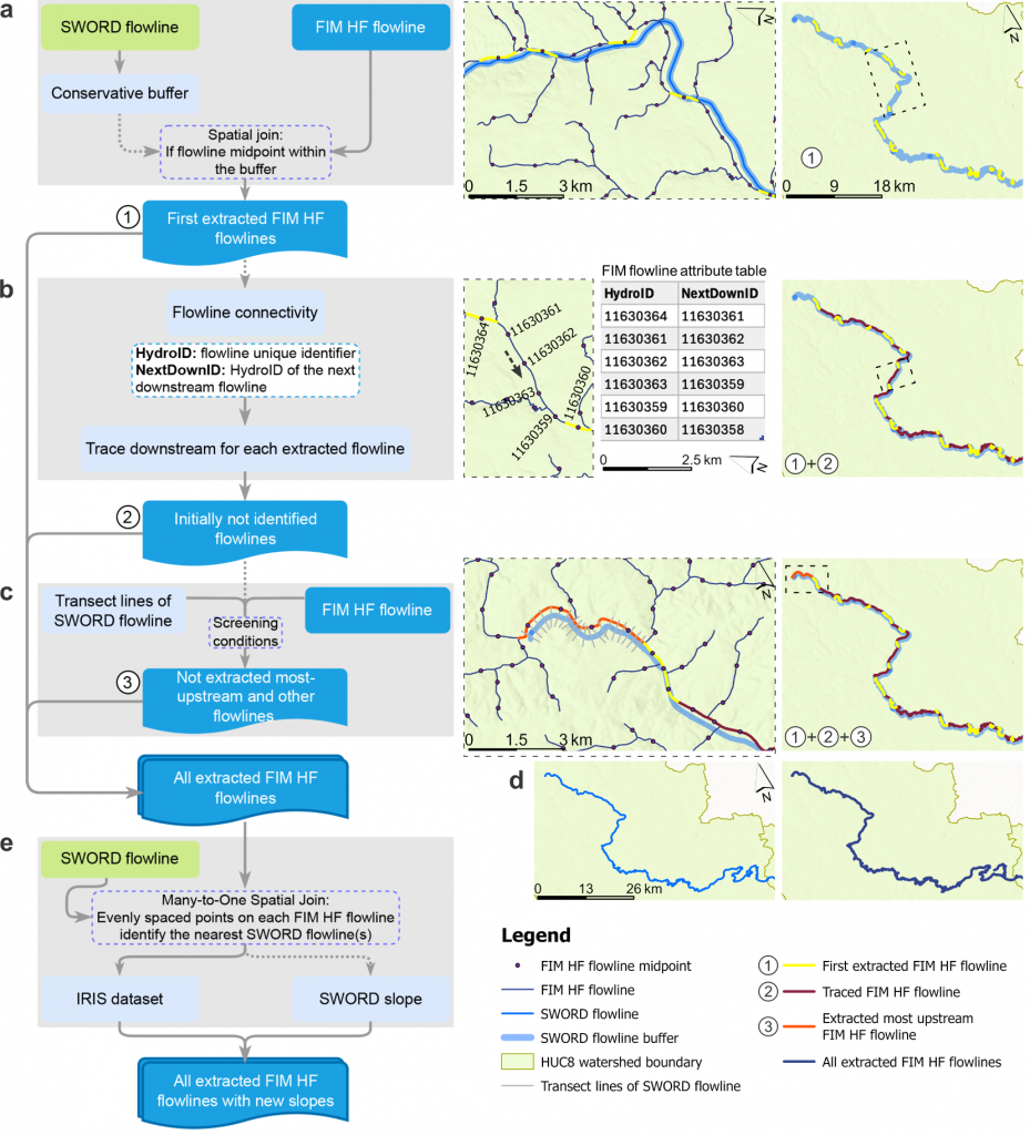
To make the new slope data usable in forecasting models, the team created a novel “spatial joining” framework, essentially a digital translator that aligns older mapping systems with newer satellite data. It enables seamless integration with operational models, including NOAA’s flood inundation mapping system known as HAND-FIM (Height Above Nearest Drainage).
Tangible Results
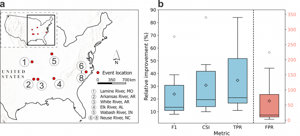
When the researchers tested their slope data in models across eight U.S. flood events, forecast accuracy improved by an average of 31%.
“The first time we tested the IRIS slopes in a live scenario, the difference in the flood maps was obvious,” Chen said.
Even in cases of slight overprediction, the new models proved more reliable than before, giving emergency managers better guidance during critical moments.
Real-World Impact
The new datasets have already been integrated into NOAA’s operational flood inundation framework. More accurate predictions can help communities respond faster, reduce property damage and save lives.
While the current datasets focus on the U.S., the spatial joining framework is designed to scale globally, which enables better data exchange and supports enhanced flood and hydrologic modeling around the world.
“Accurate input data like river slope is foundational,” Chen said. “Without it, even the most advanced models fall short.”
What’s Next
With the new foundation in place, the team is expanding their work. They’re developing global monthly river slope datasets using NASA’s Surface Water and Ocean Topography (SWOT) mission and studying how slopes shift during specific flood events.
They have also released their spatial joining tool as open-source Python code, making it available for researchers and forecasters around the world. For CIROH and its partners, it is another step toward smarter, more reliable flood prediction that is helping communities get the information they need when they need it most.
About CIROH
The Cooperative Institute for Research to Operations in Hydrology (CIROH) is a NOAA Cooperative Institute hosted at The University of Alabama and supported by the National Weather Service. As a unique national consortium with 28 partner institutions, CIROH unites academic, government and private sector partners to co-produce research that enhances operational water prediction capabilities and informs critical decision-making for issues like floods, droughts and water quality. Through its interdisciplinary research, educational initiatives and outreach programs, CIROH advances NOAA’s water prediction services with new techniques such as artificial intelligence and remote sensing, equips the next generation of water-resource professionals with essential skills and fosters public and stakeholder engagement to support federal agency and private sector needs. CIROH transforms scientific innovations into practical solutions and operational tools that boosts the delivery of actionable water intelligence, increases effectiveness of water resources management, promotes community resilience and informs decision-makers across the United States.